the Lost City of the Incas Machu Picchu

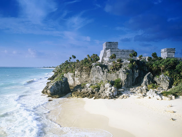
Probably everyone alive has ever heard about the world’s most dramatic ruins, the Machu Picchu. Machu Picchu is a city located high in the Andes Mountains in modern Peru. It lies 43 miles northwest of Cuzco at the top of a ridge, hiding it from the Urabamba gorge below. The ridge is between a block of highland and the massive Huaynac Picchu, around which the Urubamba River takes a sharp bend. The surrounding area is covered in dense bush, some of it covering Pre-Colombian cultivation terraces.

Machu Picchu was built around 1450, at the height of the Inca Empire.It was abandoned just over 100 years later, in 1572, as a belated result of the Spanish Conquest.It is likely that most of its inhabitants died from smallpox introduced by travelers before the Spanish conquistadores arrived in the area.[citation needed] The latter had notes of a place called Piccho, although there is no record of the Spanish having visited the remote city. The types of sacred rocks defaced by the conquistadors in other locations are untouched at Machu Picchu.
Hiram Bingham theorized that the complex was the traditional birthplace of the Incan "Virgins of the Suns".More recent research by scholars such as John Rowe and Richard Burger, has convinced most archaeologists that Machu Picchu was an estate of the Inca emperor Pachacuti.The site was selected because of its position relative to sacred landscape features such as its mountains, which are purported to be in alignment with key astronomical events important to the Incas.
Another theory maintains that Machu Picchu was an Inca llaqta, a settlement built to control the economy of conquered regions. Yet another asserts that it may have been built as a prison for a select few who had committed heinous crimes against Inca society. An alternative theory is that it is an agricultural testing station. Different types of crops could be tested in the many different micro-climates afforded by the location and the terraces; these were not large enough to grow food on a large scale, but may have been used to determine what could grow where. Another theory suggests that the city was built for the gods to live in, or for the coronation of kings.
As Pachacuti conquered new territory, he built settlements and connected them with a web of roads. Machu Picchu was the largest and most magnificent of all these communities. It was not a fortress, but the sight of it looming high above the Urubamba valley may have intimidated the lowland rain forest tribes who were hostile to the Incas.
Although the citadel is located only about 80 kilometers (50 miles) from Cusco, the Inca capital, the Spanish never found it and consequently did not plunder or destroy it, as they did so many other sites.Over the centuries, the surrounding jungle grew over much of the site, and few outsiders knew of its existence.
On 24 July 1911, Hiram Bingham announced the find of Machu Picchu to scholars. An American historian employed as a lecturer at Yale University, Bingham had been searching for the city of Vilcabamba, the last Inca refuge during the Spanish conquest. He had worked for years in previous trips and explorations around the zone. Pablito Alvarez, a local 11 year-old Quechuas boy, led Bingham up to Machu Picchu.Some Quechuas lived in the original structures at Machu Picchu.
Bingham started archaeological studies and completed a survey of the area. He called the complex "The Lost City of the Incas", which was the title of his first book. Bingham made several more trips and conducted excavations on the site through 1915, collecting various artifacts which he took back to Yale. He wrote a number of books and articles about the discovery of Machu Picchu.
A complete overview of the site as seen from Huayna Picchu
The site received significant publicity after the National Geographic Society devoted their entire April 1913 issue to Machu Picchu.
In 1981 Perus declared an area of 325.92 square kilometers surrounding Machu Picchu as a "Historical Sanctuary". In addition to the ruins, the sanctuary includes a large portion of the adjoining region, rich with flora and fauna.
In 1983 UNESCO designated Machu Picchu a World Heritage Site, describing it as "an absolute masterpiece of architecture and a unique testimony to the Inca civilization".
The World Monuments Fund placed Machu Picchu on its 2008 Watch List of the 100 Most Endangered Sites in the world because of environmental degradation. This has resulted from the impact of tourism, uncontrolled development in the nearby town of Aguas Calientes, which included a poorly sited tram to ease visitor access, and the construction of a bridge across the Vilcanota River, which is likely to bring even more tourists to the site, in defiance of a court order and government protests against it.

Man sitting on ruins, hand-colored glass slide by Harry Ward Foote, who accompanied Hiram Bingham to Machu Picchu, 1911
Although Bingham was the first person to bring word of the ruins to the outside world, other outsiders were said to have seen Machu Picchu before him. Simone Waisbard, a long-time researcher of Cusco, claims that Enrique Palma, Gabino Sánchez, and Agustín Lizárraga left their names engraved on one of the rocks at Machu Picchu on 14 July 1901. In 1904, an engineer named Franklin supposedly spotted the ruins from a distant mountain. He told Thomas Payne, an English Christian missionary living in the region, about the site, Payne's family members claim. They also report that in 1906, Payne and fellow missionary Stuart E. McNairn (1867–1956) climbed up to the ruins.
The site may have been discovered and plundered in 1867 by a German businessman, Augusto Berns.[8] There is some evidence that a German engineer, J. M. von Hassel, arrived earlier. Maps found by historians show references to Machu Picchu as early as 1874

Machu Picchu lies in the southern hemisphere, some 13 degrees south of the equator.It is 80 kilometers northwest of Cusco, on the crest of the mountain Machu Picchu, located about 2,450 metres (8,040 ft) above mean sea level, over 1,000 metres (3,300 ft) lower than Cusco, which has an altitude of 3,600 metres (11,800 ft).As such, it had a milder climate than the Inca capital. It is one of the most important archaeological sites in South America, one of the most visited tourist attractions in all of Latin Americaand the most visited tourist attraction in Peru.

The ruins of Machu Picchu are divided into two main sections known as the Urban and Agricultural Sectors, divided by a wall. The Agricultural Sector is further subdivided into Upper and Lower sectors, while the Urban Sector is split into East and West sectors, separated by wide plazas.
The central buildings of Machu Picchu use the classical Inca architectural style of polished dry-stone walls of regular shape. The Incas were masters of this technique, called ashlar, in which blocks of stone are cut to fit together tightly without mortar. Many junctions in the central city are so perfect that it is said not even a blade of grass fits between the stones.
Some Inca buildings were constructed using mortar, but by Inca standards this was quick, shoddy construction, and was not used in the building of important structures. Peru is a highly seismic land, and mortar-free construction was more earthquake-resistant than using mortar. The stones of the dry-stone walls built by the Incas can move slightly and resettle without the walls collapsing.
A llama at Machu Picchu.
Inca walls had numerous design details that helped protect them against collapsing in an earthquake. Doors and windows are trapezoidal and tilt inward from bottom to top; corners usually are rounded; inside corners often incline slightly into the rooms; and "L"-shaped blocks often were used to tie outside corners of the structure together. These walls do not rise straight from bottom to top but are offset slightly from row to row.
The Incas never used the wheel in any practical manner. Its use in toys demonstrates that the principle was well-known to them, although it was not applied in their engineering. The lack of strong draft animals, as well as steep terrain and dense vegetation issues, may have rendered the wheel impractical. How they moved and placed the enormous blocks of stones remains a mystery, although the general belief is that they used hundreds of men to push the stones up inclined planes. A few of the stones still have knobs on them that could have been used to lever them into position; it is believed that after the stones were placed, the Incas would have sanded the knobs away, but a few were overlooked.
The space is composed of 140 structures or features, including temples, sanctuaries, parks, and residences that include houses with thatched roofs. There are more than one hundred flights of stone steps –often completely carved from a single block of granite –and numerous water fountains. These were interconnected by channels and water-drains perforated in the rock that were designed for the original irrigation system. Evidence suggests that the irrigation system was used to carry water from a holy spring to each of the houses in turn.
According to archaeologists, the urban sector of Machu Picchu was divided into three great districts: the Sacred District, the Popular District to the south, and the District of the Priests and the Nobility.
Temple of the Sun at Machu Picchu
Located in the first zone are the primary archaeological treasures: the Intihuatana, the Temple of the Sun and the Room of the Three Windows. These were dedicated to Inti, their sun god and greatest deity. The Popular District, or Residential District, is the place where the lower-class people lived. It includes storage buildings and simple houses.
The royalty area, a sector for the nobility, is a group of houses located in rows over a slope; the residence of the Amautas (wise persons) was characterized by its reddish walls, and the zone of the Ñustas (princesses) had trapezoid-shaped rooms. The Monumental Mausoleum is a carved statue with a vaulted interior and carved drawings. It was used for rites or sacrifices.
As part of their road system, the Incas built a road to the Machu Picchu region. Today, tens of thousands of tourists walk the Inca Trail to visit Machu Picchu each year. They acclimatise at Cusco before starting on the two- to four-day journey on foot from the Urubamba valley, walking up through the Andes mountain range to the isolated city.
The people of Machu Picchu were connected to long-distance trade, as shown by non-local artifacts found at the site. As an example, Bingham found unmodified obsidian nodules at the entrance gateway. In the 1970s, Burger and Asaro determined that these obsidian samples were from the Titicaca or Chivay obsidian source, and that the samples from Machu Picchu showed long-distance transport of this obsidian type in pre-hispanic Peru.
The Guardhouse is a three-sided building, with one of its long sides opening onto the Terrace of the Ceremonial Rock. The three-sided style of Inca architecture is known as the wayrona style.

In 2005 and 2009, the University of Arkansas made detailed laser scans of the entire Machu Picchu site and of the ruins at the top of the adjacent Huayna Picchu mountain. The university has made the scan data available online for research purposes.
In January 2010, heavy rain caused flooding which buried or washed away roads and railways leading to Machu Picchu, trapping more than 2,000 locals and over 2,000 tourists, who were taken out by airlift. Machu Picchu was temporarily closed,but it reopened on 28 February 2010.

The Intihuatana ("sun-tier") is believed to have been designed as an astronomic clock or calendar by the Incas
The Intihuatana stone is one of many ritual stones in South America. These stones are arranged to point directly at the sun during the winter solstice. The name of the stone (coined perhaps by Bingham) is derived from the Quechua language: inti means 'sun', and wata- is the verb root 'to tie, hitch (up)' ('huata-' is simply a Spanish spelling). The Quechua -na suffix derives nouns for tools or places. Hence inti watana is literally an instrument or place to 'tie up the sun', often expressed in English as "The Hitching Post of the Sun". The Inca believed the stone held the sun in its place along its annual path in the sky. At midday on October 27 and February 14, the sun stands almost above the pillar—casting no shadow at all. Researchers believe that it was built as an astronomic clock or calendar.
Concerns over tourism
Machu Picchu is a UNESCO World Heritage Site. Since its discovery in 1911, a growing number of tourists visit Machu Picchu, reaching 400,000 in 2003.As Peru's most visited tourist attraction and major revenue generator, it is continually threatened by economic and commercial forces. In the late 1990s, the Peruvian government granted concessions to allow the construction of a cable car and development of a luxury hotel, including a tourist complex with boutiques and restaurants. Many people protested against the plans, including members of the Peruvian public, international scientists, and academics, as they were worried that the greater numbers of visitors would pose tremendous physical burdens on the ruins. Many protested a plan to build a bridge to the site as well.[20] A no-fly zone exists above the area.UNESCO is considering putting Machu Picchu on its List of World Heritage Sites in Danger.
During the 1980s a large rock from Machu Picchu's central plaza was moved out of its alignment to a different location to create a helicopter landing zone. Since the 1990s, the government has forbidden helicopter landings there. In 2006 a Cusco-based company, Helicusco, sought to have tourist flights over Machu Picchu and initially received a license to do so, but the government quickly overturned the decision.
View of Machu Picchu from Huayna Picchu, showing the Hiram Bingham Highway used by tour buses to and from the town of Aguas Calientes
Controversy with Yale University
In 1912 and 1914–15, Bingham excavated treasures from Machu Picchu—ceramic vessels, silver statues, jewelry and human bones—and took them from Peru to Yale University in the United States for further study, supposedly for a period of 18 months. Yale has retained the artifacts until now, under the argument that Peru did not have the infrastructure or proper conditions to take care of the pieces.
Eliane Karp, an anthropologist who is married to the former Peruvian President Alejandro Toledo, accused Yale of profiting from Peru's cultural heritage by claiming title to thousands of pieces removed by Bingham. Many have been on display at Yale's Peabody Museum since. Yale returned some of the artifacts to Peru, but the university kept the remainder, claiming its position was supported by federal case law involving Peruvian antiquities.
On 19 September 2007, the Courant reported that Peru and Yale had reached an agreement regarding the requested return of the artifacts. The agreement includes sponsorship of a joint traveling exhibition and construction of a new museum and research center in Cusco about which Yale will advise Peruvian officials. Yale acknowledges Peru's title to all the excavated objects from Machu Picchu, but Yale will share rights with Peru in the research collection, part of which will remain at Yale as an object of continuing study.
On 19 June 2008, National Geographic Society's vice-president Terry Garcia was quoted by daily La República. "We were part of this agreement. National Geographic was there, we know what was said, the objects were lent and should be returned."
In media
The 1954 film Secret of the Incas was filmed by Paramount Pictures on location at Cusco and Machu Picchu, the first time that a major Hollywood studio filmed on site. Five hundred indigenous people were hired as extras in the film.
Machu Picchu is also featured prominently in the 2004 film The Motorcycle Diaries, a biopic based on the 1952 youthful travel memoir of Marxist revolutionary Che Guevara. A review noted, "The scenes at Machu Picchu are worth watching several times over."
The song "Kilimanjaro" featuring Rajinikanth and Aishwarya Rai, from the 2010 Tamil film, Endhiran, was filmed at the location in September 2008.


Comments
Post a Comment